Zero Trail Miles
Sierra High Route
Tomorrow my son Kevin and I begin our trek on the Sierra High Route. We hope to complete it in 20-ish days, in time for Kevin to return to college. This mostly off trail route, parallel to and higher than the John Muir Trail, was designed by Steve Roper. You can read all about it on Wikipedia, or better yet in Roper’s guide book, not surprisingly called: Sierra High Route. The significant details are:
- Start at Kings Canyon, Roads End
- Hike north about 200 miles
- Climb over 33 major Sierra passes
- Exit at Twin Lakes, above Bridgeport
Unlike previous adventures, this one is not about the trail. It is about the passes. Attempting the route is a bit like participating in the American Ninja Warrior. Each pass presents a different physical or mental challenge, and you cannot move on to the next challenge, until you pass the current one.
The challenge passes, in order of appearance from south to north, are: Copper Creek (1), Grouse Lake (2), Goat Crest (3), Gray (4), White (5), Red (6), Frozen Lake (7), Mather (8), Cirque (9), Potluck (10), Knapsack (11), Muir (12), Snow-Tongue (13), Puppet (14), Feather (15), White Bear (16), Gabbot (17), Bighorn (18), Shout-of-Relief (19), Mammoth (20), Nancy (21), Inconspicuous (22), Whitebark (23), Overlook (24), Glacier Lake (25), Blue Lake (26), Vogelsang (27), Tuolumne (28), Mine Shaft (29), Spuller-Maul (30), Sky Pilot Col (31), Stanton (32), and Horse Creek (33)
We are staging in Clovis California. I have just finished guiding a Fitpacking trip that included the Rae Lakes Loop in King’s Canyon National Park. I came out at Roads End, the exact same trailhead where the Sierra High Route (SHR) starts. I spoke to a ranger on the way out and begged for our SHR permit. They normally only give it out between 1:00 and 4:30 the day before, or after 7:00am the day of. I reminded him that the climb out of the canyon is over 6,000 feet, and we will want to start as early as possible. Luckily, he is scheduled to hike up Copper Creek trail on the same morning. He smiled, said “You’re right,” and issued the permit.
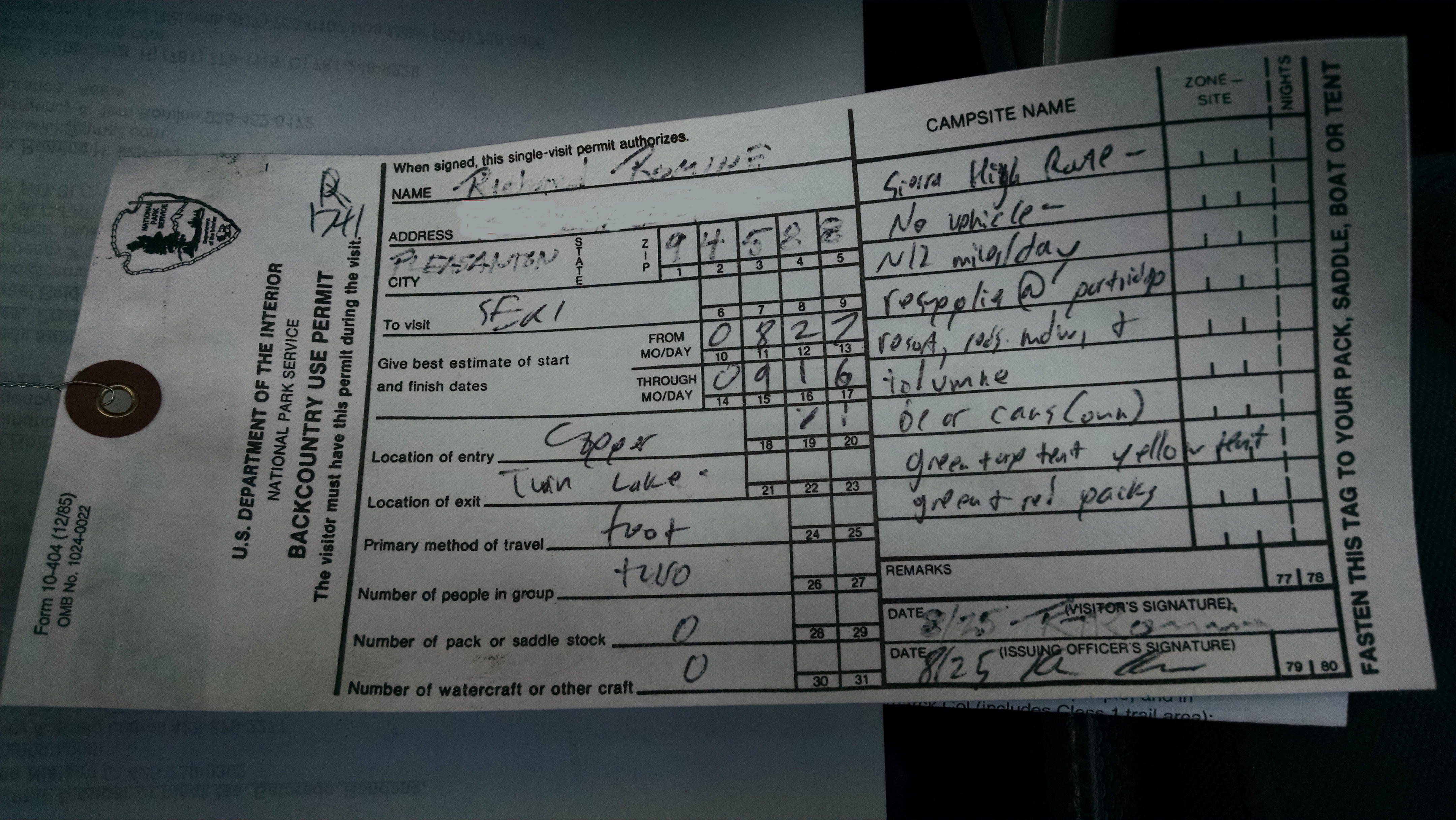
Sierra High Route Permit
Before the Rae Lakes trip, I tried my best for some “pay it forward from my PCT trip” karma by picking up two hitch hiking backpackers. They were a father and son team completing the Sierra High Route in the southern direction, opposite of our northern plan. The father was wearing a green ULA Circuit pack, exactly like mine. The son had a red ULA Circuit, exactly like Kevin’s. They were very healthy looking Canadians who said the trail had beaten them. They were making only about 5 miles a day in the talus and boulder fields, and had to jump off the High Route and on to the John Muir Trail several times. They said they would have needed 30 days or more to complete it. I was not very happy hearing their stories, and almost sorry I picked them up.
After Rae Lakes Loop, I do not have time to go home. My wife Terri rents a one-way drop Enterprise rental car and drives Kevin to Clovis. I do laundry, then pack gear and food for the first five days.
If there is one thing important to bring on a backpacking trip, it is probably a backpack. Kevin appears to be doing everything he can to break the Canadian bad karma by leaving his new red ULA Circuit at home. Too far to go get, Kevin decides to simply carry my “too large for this kind of trip” guiding backpack. To reduce some of the weight, I remove the top part of the pack, known as the brain. Kevin apparently has already reduced his own brain weight.
Tomorrow, Terri will drive us to the Copper Creek trailhead in our car, which I had driven here for the Rae Lakes trip. In celebration of the National Park Service 100 year anniversary, we are hoping they waive the $30 park entrance fee.